Thursday, August 2, 2012

Sint Maarten, Dutch West Indies (DWI)


   On 3 May 2012 I left San Diego and drove to Costa Mesa.  My long time friend, JoAnn Vanderwerf, her husband Ron and I caught the red-eye from LAX to Sint Maarten.  They had been after me for years to go with them but I begged off because I spent my vacations with family.  BUT, now that I am retired, there are no more excuses.  Mary and Brian, some friends from Huntington Beach, met us there a couple of days after we arrived.
   We got to our rooms about 4 O'Clock the next afternoon (4 May 2012).  We ate dinner at a beach bar and I was introduced to my new favorite mixed drink:  BBC.  Don't ask me what is in it, but it is VERY good.  We stayed 16 days, so I had quite a few of them.  Yum, yum!
   The Dutch side of the island is called Sint Maarten, people speak English, and business is done in the U.S. dollar. However, the French half is called  Saint Martin (different spelling) everyone is expected to speak French, and use the Euro.  Some residents act offended if people do not speak French.  We stayed on the Dutch side most of the time.  We vacationed at the Atrium Resort on Simpson Bay.  Ron and JoAnn go every year because the 5th of May is Ron's Birthday.

                                                                                   One of the places we went to at least every other day was Phillipsburg, the capital of the Dutch side.  Cruise ships dock at the Phillipsburg harbor.  On wednesdays there are usually 3 Cruise ships in port.
   The beach in Phillipsburg.  It was about 2 O'clock in the afternoon and in the mid '70's but very few people (mostly tourists) on the beach.  I guess when you live in paradise, you do not know what you have.
   The main pier in Phillipsburg.  If you look at the southern horizon beyond the third light pole, the island of Saba is barely visible. 
   This is Mullet Bay on the North-western coast.  In less than 15 minutes, I was red as a lobster.  I had put on SPF 50 before going into the water, but I failed to put it back on after coming out.  This was the second or third day of our vacation.  Needless to say, I was much more careful the rest of our stay.
   This is the main road between the Dutch & French sides.  One day we went over to the other side just to see what was there.  The sign on the right announces that you are now in French territory.
   One of the main tourist attractions is watching airplanes arrive and take-off at the airport (on the Dutch Side).  Planes come in from the north west, cross a narrow beach and a two lane road.  The landing gear barely clears a six foot fence next to the road.  As planes prepare for take off, they taxi all the way to the fence to turn around.  When they take off, they are headed towards the south east.  Directly in front of the planes is a ridge of low lying mountains.  The planes must bank to the right as soon as their wheels leave the tarmac to avoid hitting the ridge.  While we were watching, a lady stepped over the guard-rail to take a picture while a plane was turning around.  The exhaust from the engines blew her over.  She was lucky and landed on her butt.  She could have been blown over the guardrail and run over by a car.  (By the way, the guy in the white shorts with the black backpack taking a picture is Ron Vanderwerf!  I was sitting at the beach bar not about to be blown away by the plane)
  
    The sea water in the Caribbean is so blue and as warm as a bathtub.  It has so much salt in it that floating along with the tide is effortless, very relaxing.  We spent entire days lounging on beach chairs, under umbrellas, and sipping BBC's when we were not in the water.  Sunset on Simpson's Bay.
   The marina at Simpson's Bay was beautiful in the early morning.  We arrived at 7:30 am to take the ferry over to Saint Barthelemy (St. Bart's).
   The ride over was rough, the captain said it was because we were going against the tide.  Several people, myself included, got sick.  Going back to St. Maarten was much smoother so no one got sick.  However, I had visited a pharmacy on St. Bart's and purchased ($20) some wrist bands that the pharmacist recommended for motion sickness.  I definitely wore them.  Whatever the reason, I did not get sick going back.
  
  The beach at St. Bart's.  The one thing I discovered about St. Bart's is that it is way over priced.  I wanted to buy a souvenir but was unable to find anything under 10 Euro ($15).  We ate lunch at a beach bar.  I had two BBC's and an order of sweet potato fries.  My portion of the bill equated to $39.  Unlike the free beach chairs at Simpson Bay, the beach chairs on St. Bart's were rented for 15 Euro per day ($22), since we were only at the beach for a little over an hour, we did not rent them.   Overall, I was disappointed with our day trip.  If I go again next year, we will go to Anguilla and swim with the Dolphins and not go back to St. Bart's.
   On the flight back, we were upgraded to first class.  What a way to end a dream vacation.  I sat next to the nicest young man I have met in a long time.  He helped me by putting my suitcase in the overhead bin when I was taking my seat.  He had the biggest ring on his finger with a sapphire about ten times as big as the one on my ring finger.  For the first two or three hours we didn't talk much.  After lunch I asked him where he lived.  He said his home was in Miami.  Then I asked why he was going to LA.  He said that he was going to LA to make some commercials for ESPN.  He said something about football and I told him that I don't like football.  He just grinned.
   Like an idiot, I asked him what his name was so I could say that I had sat next to him from Miami to LA.  He just grinned again.  We talked about Sint Maarten and some of the things I had done.  I told him I was headed home and that I had a couple of hours drive before I would be home.  He said that ESPN was sending a driver for him so he didn't have to drive in the LA traffic.  He said that they were putting him in a four star hotel on the beach in Santa Monica.  (It still didn't dawn on me that I was talking to a famous person.  Talk about dense!)
   When the flight ended, he got my carry-on down for me, we wished each other luck and he disappeared.  At the baggage carrousel a man approached me asking what "Tim" had been talking to me about.  I asked him "Tim who?"  He said "Tim Brown of the Oakland Raiders, you sat next to him for six hours!"  I had no clue.  After I got home, I Googled Tim Brown.  That was him, but he is no longer with the Oakland Raiders, he has retired.  Just like me, but he is much younger.

Wednesday, July 4, 2012

Canaveral National Sea Shore / Merritt Island / Lone Cabbage Airboat Rides

     When I left Savannah, it was late in the afternoon.  As soon as I crossed the line between Georgia and Florida, I saw a WalMart Super Center - I stopped for the night.  
     When I parked, there was one other RV, from Colorado, in the parking lot.  I fixed my dinner and cleaned up the kitchen.  Then I made a list of groceries that I needed and headed inside.  When I back came out, a little over an hour later, there were many RVs in the lot.
     I put the groceries away and then walked around looking at the license tags and counting - there were a total of 47 RVs in the lot.  There was 1 each from California (mine), Colorado, and Alaska.  The remainder were all from somewhere in Canada:  Ontario, Quebec, Toronto, NW Territory, etc.  The Snowbirds had arrived.
     The next day, I made my way south to another National Park:  Canaveral National Seashore (CNS).  According to the National Park System Map the CNS headquarters are located at 308 Julia Street in Titusville FL.
     However, when I got there I determined that the location is not within the boundaries of the park.  Instead, it is a business office.  They do not have stamps, brochures, maps, souvenirs, or information.  The receptionist seemed to be uncertain how to answer any of my questions, but she was able to provide directions to a preserve entrance.  
     If I wanted to see the entire Sea Shore I would have had to enter from New Smyrna Beach which meant backtracking, 29 miles, almost to Daytona Beach.  But there is access from Titusville. So, to get to the preserve, I had to first cross the intracoastal waterway and access Merritt Island. 


National Wildlife Refuge Center:
     As a result, I got to see something I would not have seen had I entered from the north end.  I probably would not have known it was there.  About 4 miles east of Titusville, one encounters the National Wildlife Refuge Center.
     The portion of the island that the public can access is relatively small in comparison to the size of the preserve.  In the grasses at the top of the picture there were many varieties of water birds.  Something, probably an Alligator, had spooked them because they had just taken flight.  Some can still be seen in the sky on the left. 
     The park service has built about a mile of boardwalk through the wilderness.  The vegetation species are labeled to allow enhancement of visitors' experiences.
     The proximity to the coast keeps the temperature mild.  Spanish Moss is dripping from the trees.
     Visitors are warned before entering the Boardwalk that they might encounter Alligators.  Signs are posted frequently to remind visitors that these are wild animals.
     This is a grass marsh (according to the posted sign) that is home to almost 1,000 different species of animals - they must be hiding.


Canaveral National Sea Shore:
     After leaving the Wildlife Refuge, I continued on a few miles to the Sea Shore - Playalinda Beach.  Between the road and the beach there is a large berm that appears to be man-made.  The berms have vegetation to keep the surf from washing them away.
     There are no picnic areas, food stands, showers, or drinking water.  However, there are public restrooms.  Only between May 30 and September 1 are Lifeguards on duty - so while I was there the beaches were relatively vacant.  There are stairs leading up the berms from the parking lots and then back down to to beach.
     Driving south and then west I could see the Kennedy Space Center in the distance.  Just to the left of the center of this picture one can see the tower beyond the intracoastal waterway.

     Another view of the Kennedy Space Center (the small grey box at the center).
     Normally I take a picture of the official sign as I enter a park.  However, since I entered from the center of the island, rather than at New Smyrna, I only saw a sign as I was leaving the park...


Melbourne Florida:
     One of the reasons for my trip south, besides my goal to see all of the US National Parks, was to see a High School friend that I had not seen since 1965, Linda (nee Beeler) McDaniel.  She and her husband Woody McDaniel had moved to Florida in the early 90's.
     They have a lovely home adjacent to a pond with a resident Alligator.  Even though we had not seen each other in so many years, we were still the same people.  We had changed in looks only.  We spent hours catching up on our lives and just visiting.  Linda suggested several activities that we could do while I was there.  We could have visited the Kennedy Space Center but one of suggestions was an airboat ride.  Since I had decided to only stay a couple of days, I opted for the airboat ride and clicked another one off of "my bucket list."  I can do the Kennedy Space Center next time.


     The Lone Cabbage Airboat Rides is just a few minutes from their home.  That is my head in the alligator's mouth. 


     Linda put her head in the alligator's mouth too.


     That is us, in the front seat (the driver took the picture).  Our ride was one hour long.


     Because of recent rains storms, the water was higher than usual.  We looked all over for alligators but did not see any.


     We saw a lot of trees and vegetation though.


     We went across tall grasses that appeared to be islands but weren't.


     When our hour was almost done, we made our way back into the dock at the Lone Cabbage.


     When I left Linda and Woody's house I had planned on stopping in Orlando to visit Disney World, The Epcot Center, and anything else that struck me.  But, I had already been gone from home for over two months and was getting homesick.  So, I headed for home.  
     I stopped in Beebe, Arkansas to visit a long time friend, Mary Morris.  
     And, because I absolutely had to, I stopped in Garland Texas to see my grand-children.  Eleven days after leaving Florida, I was finally home.

Tuesday, June 26, 2012

Congaree Swamp National Park, Savannah Georgia, and Fort Pulanski National Monument

Until the mind 20th Century, Congaree National Park was known as Congaree Swamp.  
According to the National Park Service (NPS), it is technically not a swamp, it is a Floodplain forest and is one of a limited number of "virgin" forests in the United States.
   In 1976 Congaree Swamp became part of the National Park System but was not declared a National Park until 2003.


Congeree NP is located southeast of Columbia, South Carolina along the Congaree River.  It represents only a fraction of the 52 million acre floodplain forest that covered more than two thirds of South Carolina in the 1800's. 


  The 24,000 acre park is all that is left.  The park protects "the largest contiguous area of old-growth bottomland hardwood forest remaining in the United States." 
I arrived at Congaree NP around 7:00 am on 31 October  2011.  The visitor's center did not open until 8:30 am so I parked, had some breakfast, watched the sun rise, and relaxed for a while.


( <-- Moss on Cypress roots)
 For most of the year (9 or 10 months) the ground is covered with 1 to 2 feet of water.  I was lucky in that I arrived during the "dry" season.  The high-waterline can be seen on the trunk of the Cypress on the left.
 A park ranger indicated that later in the month (November) the rains begin and the water will rise.  He indicated that Congaree's trees escaped large-scale cutting because of the rains and the seasonal flooding.  As a result, it was too difficult to harvest the cut trees in the waterlogged, spongy soil. 
 Logging along the Congaree River actually ceased in 1914.  But it was not until the 1950's that conservationists recognizing the need to preserve the forest as a one of its kind ecosystem.

 Two decades later it was finally brought into the protection of the NPS in response to logging's threat to the giant trees.  One of the first things the NPS did was build boardwalks for visitors.  
To protect the ecosystem, two miles of boardwalks allow people to walk around even when the river is up and, more importantly, restrict visitor access to certain areas.  
Some of the boardwalks are just a few inches above the ground while other portions are several feet tall. 
 Rustic camping and fishing are allowed.  However, there are no RV spaces or hook-ups. Fishing and camping permits can be obtained at the visitor's center.
When Cypress trees are under water for extended periods of time, they send a portion of their roots up above the water which allows them to breathe.   These roots are called "Cypress Knees" which are just about everywhere.   
 Weston Lake abuts the boardwalk along the boardwalk's southeastern edge.  When I was there, it was quite small but according to the map provided by the NPS it can be quite extensive.
If you want to visit or just more information contact:  Congaree National Park, 100 National Park Road, Hopkins, SC 29061, 803-776-4396
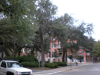
Savannah -  The next stop on my grand tour was Savannah Georgia.  My first stop was the visitor's bureau in "old Town."  I visited the historical and railroad museums attached to the visitor's center.  

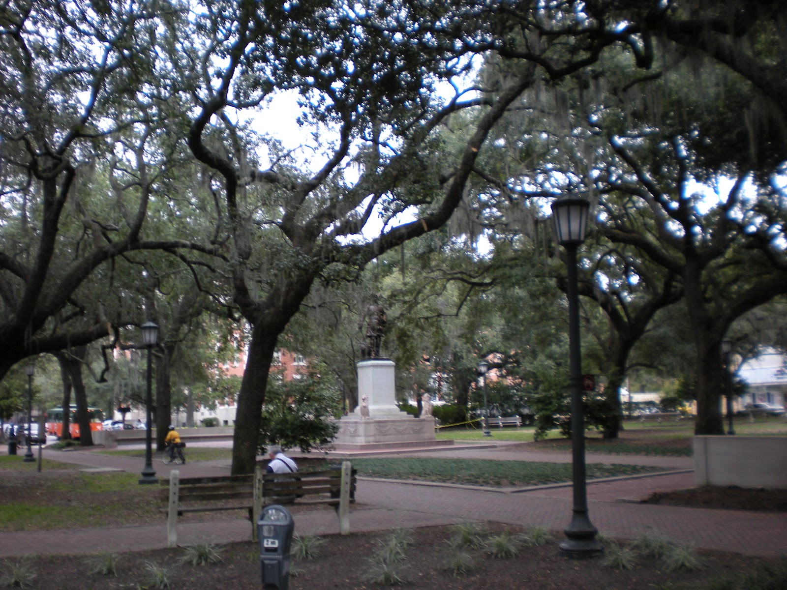
Then I drove around looking at many of the famous "squares" that were designed by General James Oglethorpe.  
Savannah's historic district has 22 squares (Ellis Square, demolished in 1954, was fully restored in early 2010).  This square is Reynolds Square and has a statue of John Wesley at its center.


According to Wikipedia, "The squares vary in size and personality, from the formal fountain and monuments of the largest, Johnson, to the playgrounds of the smallest, Crawford. Elbert, Ellis, and Liberty Squares are classified as the three "lost squares," destroyed in the course of urban development during the 1950s. Elbert and Liberty Squares were paved over to make way for a realignment of U.S. highway 17, while Ellis Square was demolished to build the City Market parking garage. The city restored Ellis Square after razing the City Market parking garage.  The garage has been rebuilt as an underground facility, the Whitaker Street Parking Garage, and it opened in January 2009. The newly restored Ellis Square opened in March 2010.  Separate efforts are now under way to revive Elbert and Liberty Squares."


Among the historic homes that have been preserved are: the Pink House,  the Sorrel Weed House, Juliette Gordon Low's birthplace, theGreen-Meldrim House, the Owens-Thomas House, the William Scarbrough House, and the Wormsloe plantation of Noble Jones. The Mercer-Williams House, the former home of Jim Williams, is the main location cited in the book Midnight in the Garden of Good and Evil

 Most of the squares function as roundabouts  which, for the most part, eliminates the need for traffic lights in the historic area.
Forsythe Park (square) has a Confederacy Memorial at its center. 
 In 1751, Savannah was designated the Colonial Capital of Georgia, hence the Capital building.  During the 1996 Summer Olympics, the sailing competitions were held in Savannah.

Historic Forts

Fort James Jackson, one mile east of Savannah's Historic District, was originally built between 1808 and 1812 to protect the city of Savannah from attack by sea.  During the American Civil War Fort Jackson became one of three Confederate forts defending Savannah from Union forces. 
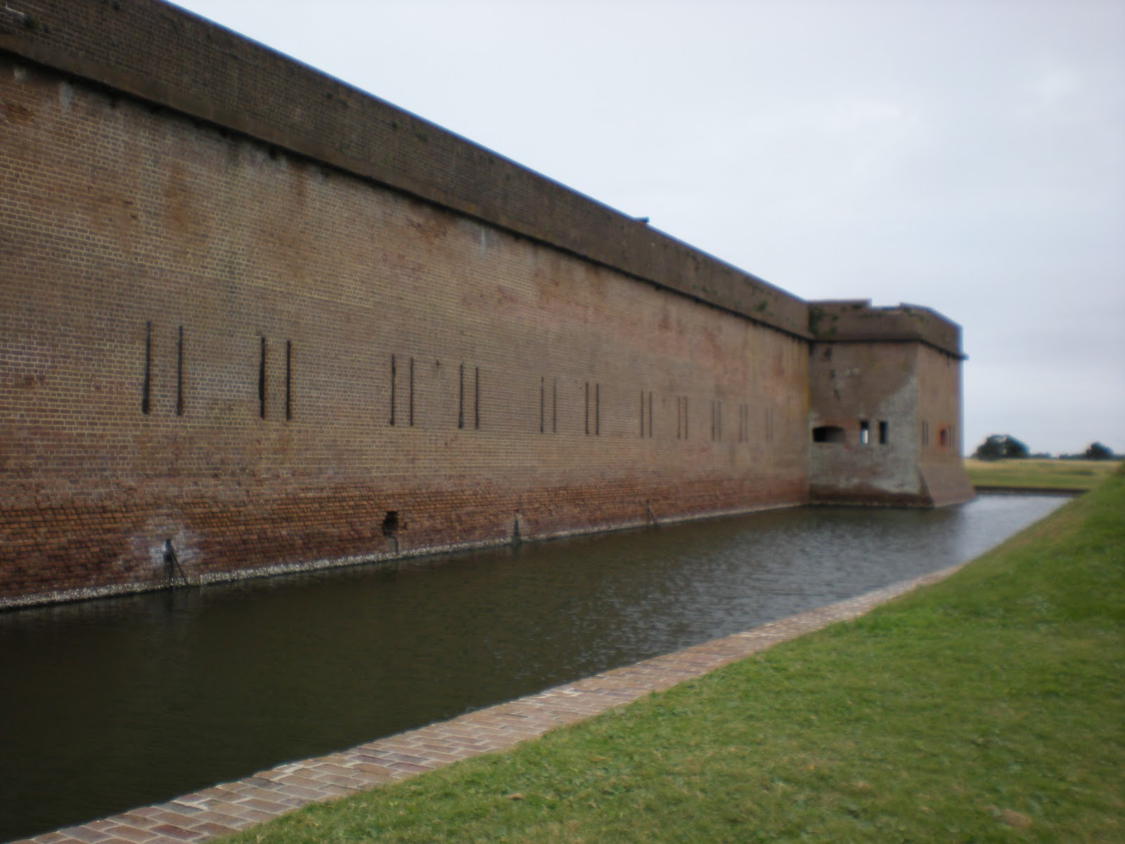
Fort Pulaski National Monument, located 17 miles (27 km) east of Savannah, preserves the largest fort that protected Savannah during the Civil War.  The Union Army attacked Fort Pulaski in 1862 with its new rifled cannon.  The new weapon effectively rendered brick fortifications obsolete.


Fort Pulaski is actually located on Cockspur Island which sits in the main channel at mouth of the Savannah River.  The National Monument includes most of Cockspur Island (containing the fort) and all of the adjacent McQueens Island. 
Following the War of 1812, President James Madison ordered a new system of coastal fortifications to protect the United States against foreign invasion.  Construction of a fort to protect the port of Savannah began in 1829 under the direction of Major General Babcock, and later Second Lieutenant Robert E. Lee, a recent graduate of West Point.  In 1833, the new fort was named Fort Pulaski in honor of Kazimierz Pulaski, a Polish soldier and military commander who fought in the American Revolution under the command of George Washington.  Pulaski was a noted cavalryman and played a large role in training Revolutionary troups.  Pulaski took part in the sieges of Charleston and Savannah.  Fort Pulaski was completed in 1847 following 18 years of construction and nearly $1 million in construction costs.


 Fort Pulaski is approached from McQueens Island via a causeway, from US 80, across the South Channel of the Savannah River.
 The fort now sits in a parklike setting. 
 Fully restored, the southeast angle of the fort that lay in ruins at the end of the 1862 bombardment looks as it did upon completion in 1851.  The fort is, as it was then, protected by a mote.  An earth berm covers and protects storerooms on the three sides of the fort.

 The actual entrance to the fort is on the south face of the structure.

The visitor's center is the circular building at the bottom of the picture.


To enter the fort, one must first cross the moat and walk between earthworks with reinforced bunkers below.

 Entrance to the main part of the fort
Entrance to one of the bunkers beneath the earthworks.  The bunkers/storerooms are connected and have multiple entrances and exits which enabled soldiers access to the defensive walls surrounding the fort while being protected from gunfire.
 View looking south from the top of the defensive walls of the fort.
 Emerging from a bunker one see a protective wall to one side with a earth berm which covers the bunker on the other side.
 View from the bunkers towards the main gate.
 Outside of the fort.
The parade ground on the right and orders from the officer of the day.
View of the Atlantic Ocean from the top of the fort.


For further information contact:  Fort Pulaski National Park, P.O. Box 30757, Savannah GA 31410 (912) 786-5787