
According to the National Park Service (NPS), it is technically not a swamp, it is a Floodplain forest and is one of a limited number of "virgin" forests in the United States.


Congeree NP is located southeast of Columbia, South Carolina along the Congaree River. It represents only a fraction of the 52 million acre floodplain forest that covered more than two thirds of South Carolina in the 1800's.

The 24,000 acre park is all that is left. The park protects "the largest contiguous area of old-growth bottomland hardwood forest remaining in the United States."

( <-- Moss on Cypress roots)


Some of the boardwalks are just a few inches above the ground while other portions are several feet tall.


Savannah - The next stop on my grand tour was Savannah Georgia. My first stop was the visitor's bureau in "old Town." I visited the historical and railroad museums attached to the visitor's center.
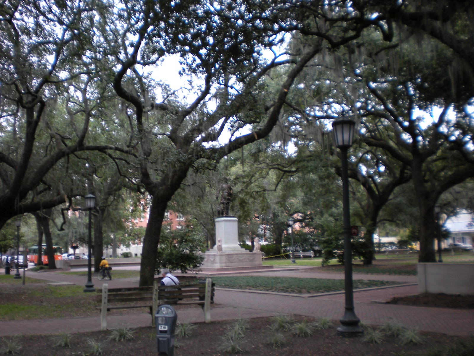
Savannah's historic district has 22 squares (Ellis Square, demolished in 1954, was fully restored in early 2010). This square is Reynolds Square and has a statue of John Wesley at its center.
According to Wikipedia, "The squares vary in size and personality, from the formal fountain and monuments of the largest, Johnson, to the playgrounds of the smallest, Crawford. Elbert, Ellis, and Liberty Squares are classified as the three "lost squares," destroyed in the course of urban development during the 1950s. Elbert and Liberty Squares were paved over to make way for a realignment of U.S. highway 17, while Ellis Square was demolished to build the City Market parking garage. The city restored Ellis Square after razing the City Market parking garage. The garage has been rebuilt as an underground facility, the Whitaker Street Parking Garage, and it opened in January 2009. The newly restored Ellis Square opened in March 2010. Separate efforts are now under way to revive Elbert and Liberty Squares."

Among the historic homes that have been preserved are: the Pink House, the Sorrel Weed House, Juliette Gordon Low's birthplace, theGreen-Meldrim House, the Owens-Thomas House, the William Scarbrough House, and the Wormsloe plantation of Noble Jones. The Mercer-Williams House, the former home of Jim Williams, is the main location cited in the book Midnight in the Garden of Good and Evil.

Most of the squares function as roundabouts which, for the most part, eliminates the need for traffic lights in the historic area.
Forsythe Park (square) has a Confederacy Memorial at its center. 
Historic Forts
Fort James Jackson, one mile east of Savannah's Historic District, was originally built between 1808 and 1812 to protect the city of Savannah from attack by sea. During the American Civil War Fort Jackson became one of three Confederate forts defending Savannah from Union forces.
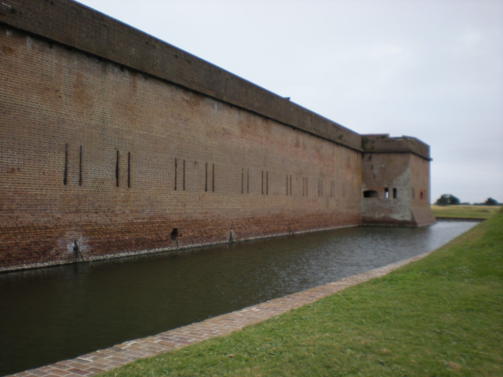
Fort Pulaski National Monument, located 17 miles (27 km) east of Savannah, preserves the largest fort that protected Savannah during the Civil War. The Union Army attacked Fort Pulaski in 1862 with its new rifled cannon. The new weapon effectively rendered brick fortifications obsolete.

Following the War of 1812, President James Madison ordered a new system of coastal fortifications to protect the United States against foreign invasion. Construction of a fort to protect the port of Savannah began in 1829 under the direction of Major General Babcock, and later Second Lieutenant Robert E. Lee, a recent graduate of West Point. In 1833, the new fort was named Fort Pulaski in honor of Kazimierz Pulaski, a Polish soldier and military commander who fought in the American Revolution under the command of George Washington. Pulaski was a noted cavalryman and played a large role in training Revolutionary troups. Pulaski took part in the sieges of Charleston and Savannah. Fort Pulaski was completed in 1847 following 18 years of construction and nearly $1 million in construction costs.


The actual entrance to the fort is on the south face of the structure.
The visitor's center is the circular building at the bottom of the picture.
To enter the fort, one must first cross the moat and walk between earthworks with reinforced bunkers below.


For further information contact: Fort Pulaski National Park, P.O. Box 30757, Savannah GA 31410 (912) 786-5787