This particular Standing Stone Circle is just a few miles from Culloden (our next stop). Both stone circles and Culloden are featured in Diana Gabaldon's "Outlander" series.
Anthropologists are uncertain why the circles were built. They theorize that they had some sort of religious function but no one knows for certain.
This stone structure is believed to have been a crematorium for the Celts. According to the signage at the entrance, this site has not been used for the past two millennia.
It sits at the eastern edge of the stone circle. The entrance to this structure is just a few feet from the stone circle.
The stones in this circle were approximately 50 to 75 feet apart. Some of them appeared to be intact, as in the foreground. While some were almost eroded away, as the two in the background are.
Are you a Harry Potter fan? The bridge used in the Harry Potter movies is really there, in Scotland. We could see it from the road to the stone circle.
Culloden is Gaelic for "back of the small pond" and is the name of a village three miles from Inverness Scotland. The adjacent moor is the site of the Battle of Culloden (or massacre depending on whose version is told) which was the final battle of the Jacobite Rising. The Scots sought to overturn the ruling Hanover government and restore the Stuart government. King James Stuart's son, Bonnie Prince Charlie was making a bid for the Scottish crown. The clans had gathered to reclaim Scotland and declare their independence from the British.
On 16 April 1746 at 1:00 AM, the British forces commanded by the Duke of Cumberland's attacked the encamped sleeping rebel Jacobite forces.
Between 1,500 and 2,000 Scots were killed or wounded while there were only 50 British killed and another 275 wounded.
The building to the right was the British commandars' headquarters. The moor beyond is where the Scots were camped.
After the battle, the men from the various clans were heaped into piles and dirt thrown over them.
There are no individual markers, just clan markers on each burial mound.
The tower on the right is where the Jacobite commanders were based.
These were the lines of battle. The number 325 next to the British marker indicates the number of british casualties, but there is no number by the rebel line to indicate how many fell.
Records indicate that there were 145 Scottish survivors. All 145 were jailed and later transported to the British colony of Carolina.
Loch Ness is 23 miles long and averages about a mile wide. At its deepest point it is about 755 feet deep. It feeds into the River Ness and the Morray Firth (Bay of Morray) on the North Sea.
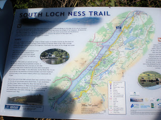
This was our first view of Loch Ness. We were at the blue rectangle with the white check mark at the top on the map above or the northern end of the Loch.
Those black things in the water are ducks, not the Loch Ness Monster. This is a view of the Loch looking to the southwest.
Did we go in the water? Yeah right! Well if sticking your fingers in counts, we did.
Everyone asks did we see Nessy? Well, here he is with his hat and sunglasses.


No comments:
Post a Comment